Global Positioning System (GPS)
The Global Positioning System has been around for a very long time. There is much information about GPS military, commercial and civilian use from the 1970s up to the present. We can pinpoint an exact location very quickly, almost instantaneously through satellite technology.
Today we have GPS technology embedded into our phones and other mobile devices. Sat/nav allows drivers to find the quickest route to their respective destinations. Well, most of the time anyway! People who have used sat/nav a lot know well how annoying the AI voice can be. I think it has vastly improved now, though satellite technology has and continues to advance.
GPS and NestForms
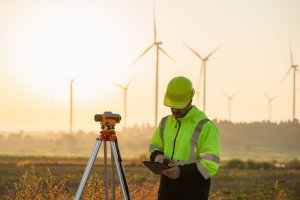
So we know what the inspection or survey is for and how the data is going to be collected. Now where are we carrying the work out? Where are we sending our people? Is it just one location or are there several? Is there a specific location, say a particular turbine within a wind farm? The GPS feature is very useful when the platform is being used as a land survey app. Is a Health and Safety audit to be carried out in a particular site or building? Are the responders interviewing people in a city centre where they can report back exactly where the survey is taking place, maybe a train station or outside a convention centre? Should we force the responder to return their location as an extra safety measure where a company has a number of staff working in a city centre or any other busy location? These are all occasions when it would be appropriate to give your exact location.

The NestForms mobile survey app gives administrators the option to create forms that give responders on the ground the opportunity to give their exact location using GPS. As the NestForms mobile form app is primarily used through mobile devices, locations can be returned to base instantaneously. This would be perfect for architects, project managers or site surveyors who may have to work at several locations within a specific period. GPS is useful in a whole host of circumstances, consider asset tracking and management. Goods might be transiting through different countries over a long time period and subject to inspection at different points during the journey. Within the insurance industry an inspector might be required to pinpoint the exact location where a road traffic accident had occurred.
Using the GPS component within a form
As the administrator, it is very easy to insert the GPS feature into a form. You simply position the component using drag and drop into the appropriate place within the form. If we have an engineer going to inspect the same piece of machinery at multiple locations, a form can be set up to include a GPS component along with a Text component requiring input on the name of the business. As I have said earlier it could be a remote wind turbine or the inspection of an asset in transit. The ability to stipulate an accurate location is important so that the company or agency can confirm quickly whether the location is correct.
Within the component you can select degrees, minutes and seconds (DMS) which is an older format for returning geographic coordinates. Providing coordinates in Decimal Degrees (DD) is the next and most commonly used option when returning locations.
Map select
By enabling this function you can choose the coordinates within the map view. One of the reasons why people might use Map select is to cater for when colleagues on the ground are unable to obtain a GPS signal in certain environments. A good example when using Map select would be if an agricultural worker has to return their position within certain land areas. Within asset management, goods might need to be inspected or tracked at remote locations, whilst in transit through road or rail. A person carrying out street surveys may find it difficult to obtain a signal within some built up areas. A tree surgeon might wish to pinpoint a remote area where they will be working.

KML files
When using the KML (Keyhole Markup Language) feature you can add any additional information or detail as an overlay to your map. For example, within the fishing industry, responders on vessels can return their coordinates meaning the company can create overlays on maps showing catchment areas etc. With the tree surgery example above, the agency may wish to see a map overlay of areas worked or other areas to be inspected.
Working offline
The GPS feature then is perfect for workers within the agricultural/agronomy and other industries such as forestry or fisheries working in remote locations. These are just some examples where exact locations on both Android and iOS devices can be returned without a connection. Assisted GPS or A-GPS doesn't work without a data connection, but GPS radio can still retrieve a location fix directly from the satellites if needed.
If you would like a chance to try out NestForms, you can sign up for free and your first two weeks begin with a free trial of the system as a Premium user.
If you would like to try out the various features that might be of assistance when creating your offline mobile survey forms you can find out more on the NestForms mobile survey app website.
You can also view a short video on how the app works on the homepage.
You can also learn more on how to use our formbuilder by getting a better understanding of NestForms